Investigation and evaluation on automatic methodologies for updating and verification of geospatial databases
| Team: | C. Yang, F. Rottensteiner, C. Heipke |
| Jahr: | 2017 |
| Förderung: | LGLN¹, LVermGeo², LaiV-MV³ |
| Laufzeit: | seit 2017 |
| Ist abgeschlossen: | ja |
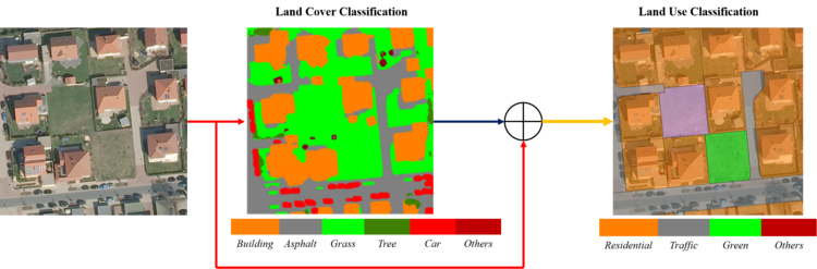
Geospatial land use databases contain important information with high benefit for several users, especially in the field of urban management and planning. The number of possible applications of such data increases with a higher level of detail, both in terms of the size of geometrical entities as well as the diversity of land use classes. Because of the fast changes of the land use due to urban growth and land use conversion, such geospatial databases become outdated quickly. This observation motivates the development of an automatic update process for large-scale land use databases. In contrast to land use, which reveals the socio-economic function of a piece of land (e.g. residential, agricultural), land cover describes the physical material of the earth’s surface (e.g. grass, asphalt). The both terms of land cover and land use relate to themselves, which means, a land use object could contain many different land cover elements to form complex structures and meanwhile, a specific land cover can be a part of different land use objects. Thus, land cover and land use classification based on remote sensing data are tasks that pursue different objectives.
Generally speaking, the assignment of class labels to image sites is land cover classification, whereas the assignment of labels to larger spatial entities, typical functional units represented by polygons, is the goal of land use classification. In our project, high-resolution aerial images are the data source for extracting the land use and land cover information, and we employ deep convolutional neural networks (CNN) to achieve these both goals with high quality results. Firstly, we do classification of land cover (semantic segmentation), and then use the generated land cover map as well as the original imageries to do classification of land use. Figure 1 shows a flowchart of this process:
- ¹ Landesamt für Geoinformation und Landesvermessung Niedersachsen
- ² Landesamt für Vermessung und Geoinformation Schleswig Holstein
- ³ Landesamt für innere Verwaltung Mecklenburg-Vorpommern
Publications
Yang, C.; Rottensteiner, F.; Heipke, C. (2018): Classification of land cover and land use based on convolution neural networks. In: ISPRS Annals of the Photogrammetry, Remote Sensing and Spatial Information Sciences IV-3, pp. 251-258.


