Digital Photogrammetry for Measuring Soil Surface (2001)
| Team: | Helge Wegmann, Folke Santel |
| Year: | 2001 |
| Duration: | 1999-2001 |
| Is Finished: | yes |
In cooperation with the National Soil Erosion Research Laboratory, Purdue University, West Lafayette (Indiana) USA
Research Groups: Close range photogrammetry
Background and goal:
Digital Elevation Models of soil surfaces are used in soil erosion research for a better understanding of erosion processes. Non-contacting techniques are used to avoid disturbance of the soil surface. So called laser scanners are used to obtain high-resolution grids (1 mm²/grid cell) from soil surfaces (up to 16 m²). The scanning devices are moving on a heavy reference frame and are thus not very practicable for field work. The time needed for one scan exceeds hours while soil surfaces may change within much shorter periods of time. For faster data acquisition and better versatility as well as for the coverage of large areas, photogrammetry is proposed to be an ideal surveying method. The system is not in contact with the soil surface, large areas can be covered by a block of images, and temporal resolution is determined by the time to take the necessary number of photographs. A camera can be easily transported on field location. This paper will describe the photogrammetric method under development at the National Soil Erosion Research Laboratory in cooperation with the University of Hanover, Institute for Photogrammetry and GeoInformation. The method is compared to one of the latest laser scanner devices. Results show that the photogrammetric technique is capable of reducing the time for data acquisition, of covering large areas large by combining multiple images, and that it has a better relative accuracy than the laser scanner.
Materials and Methods:
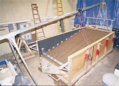
The soil surface under investigation was prepared in a laboratory flume with dimensions of 4.18 m, 2.21 m and 1.30 m length, width, and height, respectively (figure 2). A 31 % steep surface was created with sand beneath the soil material. Soil material from the Bt horizon of a Camden soil (Typic Hapludalfs) containing 23 g/Kg sand, 864 g/Kg silt, and 113 g/Kg clay, was passed through an 8 mm sieve, air dried, and a 20 cm thick layer of soil was filled in the box. A rainfall simulator was used to simulate rainstorm events.
After each rainfall experiment the surface was scanned with a laser scanner device and stereo photographs were taken. The scanner is a new development by C. Huang at the NSERL. Instead of tracking a point on the surface, a laser line is projected on the soil surface, and its signal is tracked on a CCD (charge-coupled device) sensor in a camera pointing at the soil surface.
For the photogrammetric survey a Kodak DCS 1m (monochrome) with a Leica Elmarit R 19 mm lens was used (focal length multiplier due to the ratio of 35 mm film size compared to chip size is 1.3). For coordinate measurements the software DPLX (Pollak et al. 2000) was used; the camera system was calibrated with the bundle block adjustment program BLUH (Jacobsen 2000), both programs were developed at the IPI. DPCOR (IPI Hanover) software was used for the matching of conjugate points. The program uses a least squares matching algorithm. The user can identify up to 49 pairs of homologous points in both images as start points. The algorithm follows the region growing principle to match conjugate points in stereo image pairs. Matching was carried out in image space, no orientation parameters are required. A pixel matrix in the left scene is compared to a matrix of pixels in the right scene by means of a local 6 parameter affine transformation after adjusting for contrast and brightness differences. A least squares adjustment leads to sub pixel accuracy for the matched coordinates.
Publications:
Rieke-Zapp D., Wegmann H., Santel F., Digital Photogrammetry for Soil Surface Measurements, Annual Meeting of the ASA, Nov. 5-9, Minneapolis, MN, p. 310
Rieke-Zapp D., Wegmann H., van der Ploeg R. R., Nearing M. A., Applied Photogrammetry to Evaluate Soil Surface Roughness, annual Meeting of the ASA, Oct. 31-Nov. 4., Salt Lake City, UT, p. 276
Diploma Thesis:
Bosselmann, Holger, Untersuchung der automatischen Bestimmung von Sandoberflächen mit DPCOR, 1999
Ansprechpartner: Wegmann, H.
Santel, Folke, Digitale Nahbereichsphotogrammetrie zur Erstellung von Oberflächenmodellen für Bodenerosionsversuche, 2001
[Dokument (pdf)]
Ansprechpartner: Wegmann, H., Santel, F.


